The Site
The WIPP site near Carlsbad was chosen for political, not scientific reasons. In 1957 the National Academy of Sciences (NAS) recommended salt formations as the most promising type of site for permanent underground disposal of radioactive wastes. Salt tends to creep or close in on itself and it was believed that the salt would close around the waste, burying it and sealing any possible fractures that could be release pathways. Also, it was assumed that any underground salt formation would be dry.
One of the original site criteria was that the site be at least two miles from any boreholes that went through the salt formation. When a brine reservoir was found underneath the first proposed site and the site was moved, however, no location could be found that satisfied the 2-mile buffer zone requirement. Therefore the standard was changed to 1 mile, which it remains today. (This is not the only time DOE has made standards fit the site, rather than find a site that fits the standards.)
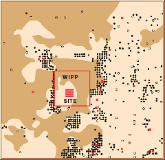 In fact, oil and gas exploration in the area skyrocketed after 1990 and there are now more than 120 oil and gas wells around the site with many more approved for the future. There would be even more wells drilled, but they are prohibited in the areas with known potash reserves until the potash has been mined. (Brown areas in the map at right are potash reserves; most of the U.S. potash mines are located near or next to the WIPP site). The repository is excavated 2150 feet underground in the Salado Formation and the potash lies in the same formation but closer to the surface.
Because there is so much oil and gas under the site, (gray areas in the drawing below-left are known and probable oil and gas resources at WIPP) DOE admits that exploratory drilling is likely to breach the repository, This is one of the most severe breach scenarios. Subsidence caused by leaving holes underground after the potash has
 been removed is another serious concern since it could lead to fracturing and more pathways for the waste to reach the environment.
The salt in which WIPP is excavated is not completely pure but is 'bedded'--salt that is periodically interrupted by beds or layers of clay and anhydrite. These layers, called interbeds or sometimes marker beds, are continuous layers that run across the entire Delaware Basin for tens--or sometimes hundreds--of miles, connecting every borehole and all the shafts at WIPP that are drilled through the interbeds. Fluids can flow through these marker beds about 1000 times more easily than they can through the salt in the Salado Formation. So the flow of fluids into and of contamination away from the repository is controlled not by salt but instead by salt mixed with clay, clay layers and fractured anhydrite layers. Open fractures in the marker beds and openings where the anhydrite and clay meet the salt can allow the water or brine to flow even faster.
During waterflooding, liquids are injected--sometimes for years--under pressures so great that they can fracture the rock into which they are injected. If they reach the WIPP site, they could fill the repository. This, now contaminated, liquid could be brought up to the accessible environment through drilling or could be pushed out of the repository by various forces and travel through the interbeds, subsidence fractures or karst channels to another borehole or directly to the accessible environment. Brine injection is so common in the Delaware Basin and has been shown to travel so far already, that it is not inconceivable that brine could be forced into the repository even during the operational life of the project.
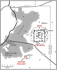 There are also numerous boreholes and wells drilled on the WIPP site itself to study the hydrology and geology of the area. (These are shown in the map at right.) Whether these plugged boreholes will be able to resist corrosion--even in the short term--is unknown. Fluid injection activities near WIPP are expected to increase with time. It appears that there will be many hundreds of holes on and around the repository which could be pathways to help fluids move into or out of the WIPP site.
Below the Site
The danger from a pressurized brine reservoir below the site is so great, that the repository location has been moved twice to avoid brine. In 1978 borehole ERDA-6 encountered brine and the original repository location was moved. In 1981 borehole WIPP-12, one mile north of the present repository also hit pressurized brine. Brine flowed to the surface at a rate of 1500 barrels per day for 40 days before the borehole was capped. The total brine outflow was about 2.5 million gallons. The repository was moved again to its present location and was sited only 2150 feet below ground in order to keep it away from brine pockets. (The salt lower down is purer and therefore has fewer interbeds in it along which water or radionuclides could migrate. The danger from brine reservoirs outweighed the benefits of the lack of interbeds, however.) Unfortunately, surfaced-based geophysical tests indicate the existence of brine in the Castile Formation directly under the present site as well.
The ERDA-9 borehole has been drilled so close to the waste panels that it could be connected by fractures to the repository underground. This borehole penetrates 53 feet into the Castile Formation. Only 200 feet of vertically fractured anhydrite separates the highly pressurized brine reservoir from ERDA-9, and potentially from the waste rooms.